dronetechnologyexpert.blogspot.com/2018/08/test.html Drone technology.expert News: dji mavic air specs
Showing posts with label dji mavic air specs. Show all posts

Thursday, September 20, 2018

DJI Phantom 4 Pro Review

Flight modes4.3mi (7km) long-range controlSensor redundancyIntelligent batteriesDJI GO 4Different productions require different flight characteristics, and the Phantom 4 Pro offers three modes for flight: P, A and S. Switching between them allows pilots to get the control they need, whether they seek smoothness, simplicity, intelligent navigation or speed. In Position Mode, TapFly, ActiveTrack, obstacle sensing and positioning features are available.

Sport Mode adds extra agility and higher speed, reaching 45 mph (72 kph). Atti Mode switches off satellite stabilization and holds the Phantom 4 Pro’s altitude. It is ideal for experienced pilots looking to capture smoother footage. Tripod Mode, which limits speed to 4mph (7kph) provides precision control for fine framing and indoor flying. Both the infrared sensing system and vision sensors are enabled in these modes for a safer flight experience.

Using brand new DJI Lightbridge HD video transmission technology, the Phantom 4 Pro has a maximum transmission range of 4.3i (7km)*. Before each flight, it scans a range of available frequencies to find and use the one with the least interference. By supporting 2.4GHz and 5.8 GHz frequency bands, it gives you more reliable control. Tightly integrated with DJI GO 4, Lightbridge video transmission also sends vital flight statistics in real time, and can be used to quickly download photos and videos to connected mobile devices.

The Lightbridge video transmission system uses advanced transmission technologies and can automatically adjust to environmental conditions. It ensures high quality, low latency image transmission across its range and offers pilots a better shooting experience. Traditional analog video transmission occupies a larger bandwidth and is more susceptible to interference. It also suffers from poor image quality and short range.

 Wi-Fi transmission also compares poorly, suffering from low latency, lengthy re-connection times, and short transmission distances due to the high cost of more powerful Wi-Fi transmission. * Unobstructed, free of interference, when FCC compliant.The Phantom 4 Pro features dual compass modules and dual IMU units, making it more reliable when compared to many helicopters and quadcopters.

 Compasses and IMUs are important sensors to ensure a stable flight and the Phantom 4 Pro constantly compares the data it receives through both pairs.

 This data is run through advanced algorithms to check accuracy and any inaccurate data is simply discarded without affecting flight, keeping flight steady and reliable.Professional aerial imaging benefits from longer flight times. The Phantom 4 Pro has a maximum flight time of 30 minutes, providing more time in the air to capture the perfect shot.

The DJI GO 4 app shows battery lifetime and calculates remaining flight times according to distance traveled and more. It will give alerts when it reaches a minimum safe amount required for a safe journey back to the takeoff point. An advanced battery management system is also in place to prevent overcharging and over draining. When placed in longer term storage, batteries will discharge power to maintain good health.When shooting aerials, the remote controller is responsible for most physical controls including piloting and capture. However, more challenging shoots require a real-time video feed, vital flight statistics and advanced settings.

 These are traditionally handled through a smart device, making the smart device essential to aerial imaging. The DJI GO 4 app is optimized for aerials and is updated along with the aircraft to ensure all features are supported. It can be used on smart devices and is available to be integrated into the DJI CrystalSky monitor, providing simple and convenient control.

 Using the DJI GO 4 app, a large number of Intelligent Flight Modes are available. It also provides access to full manual camera controls, including ISO, aperture, shutter speed, image formats, and more. Any changes in DJI GO 4 will appear almost instantly on-screen. Vital flight data and video transmission status are easy to check in-app, further enhancing control efficiency and convenience. DJI GO 4 includes editing features for quick editing and sharing to social media and even live streaming. After each flight, flight routes and data are automatically recorded and synchronized to the attached DJI GO 4 account, keeping it readily accessible for you to review. Both flight logs and data are easy to record and review.

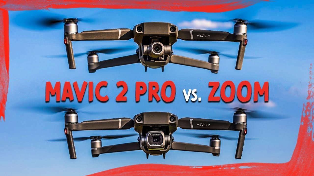
Review DJI Mavic 2 Zoom,DJI Mavic 2 Pro


Mavic 2 Zoom Powered by a 1/2.3-inch 12-megapixel sensor with up to 4x zoom, including a 2x optical zoom (24–48 mm), 4 the Mavic 2 Zoom is all about dynamic perspectives

. Capture everything from wide angle to mid-range shots for even more creative options.More Expressive Mid-Range Shots Compared to a 24mm wide angle lens, the 48mm telephoto lens compresses your perspective, enhancing the parallax effect for a classic cinematic look. 4 Now a whole new world of aerial photography is open to explore with even more epic, cinematic shots.Replay Worry-Free Way to Find a View When shooting Full HD video, 4x lossless zoom (including 2x optical zoom) gives you a closer view of faraway subjects, making unique scenes more accessible to capture at a distance.

This option also helps you maintain a safer distance from buildings, vehicles, animals, and people.Replay Quick and Accurate Focus Hybrid autofocus on the Mavic 2 Zoom combines phase and contrast detection for higher focus accuracy with an increased focus speed of up to 40% more than before. The autofocus tracking system makes subjects appear clear and sharp when zooming in and out.ReplayZoom During Flight Dolly Zoom is a new QuickShot for the Mavic 2 Zoom, offering an otherworldly perspective in a fully-integrated drone. Dolly Zoom automatically adjusts focus when flying, adding an intense, warping visual effect to your video.

 When flying manually, you can also set proper focus speed values for even more creative shot options.ReplaySuper Resolution PhotosThe Mavic 2 Zoom also has a brand new Super Resolution feature – an asset when capturing the vivid details your landscape photography deserves.

When taking a picture with a 24 mm equivalent field-of-view, 4 the camera will capture and patch nine photos with its telephoto lens, resulting in a 48-megapixel super resolution photo. Compared to ordinary panoramas, the super resolution photos retain the original look of the shooting targets with a more accurate composition.The Mavic 2 Zoom is a game changer for aerial photography. It gives me opportunities to create aerial videos in a new way. Now I can capture more details from a safe distance, and realize different visual effects with different focal lengths.Jimmy Chin Jimmy Chin is a photographer, filmmaker, and mountaineer.

 His 2015 film “Meru” won the coveted Audience Award at the Sundance Film Festival and was also on the 2016 Oscar shortlist for Best Documentary. DRONES - Freewell Gear Blog The Mavic 2 Zoom is the latest iteration of the Mavic series. DJI has built on the tremendous success and popularity of the Mavic Pro and Mavic Pro Platinum to offer more choices for creative people.

 On one hand is the Mavic Air, which is designed for more casual or entry-level drone pilots. The Mavic Air is extremely portable, utilizes DJI’s extensive knowledge of flight and image capture, and is at a price that makes it very affordable to get into flying drones. (For more details, you can read my article about Mavic Air in-depth Review) On the other hand, DJI is offering the Mavic 2 series as a drone for more demanding or experienced drone pilots. The Mavic 2 series has higher image quality, stabilization, and longer flight times than almost any other consumer drone available today.

 In other words, the Mavic 2 series is designed for people who want to push their creativity to the limits! Notes:1. Unobstructed, free of interference, when FCC compliant. Maximum flight range specification is a proxy for radio link strength and resilience. Always fly your drone within visual line of sight unless otherwise permitted.2.

 Acquired at a constant speed of 25 kph, free of wind. Actual flight time may vary because of the environment and use of flight modes.3.

 Omnidirectional Obstacle Sensing includes left/right, up/down, and forward/backward. Sensing for left/right directions is only available with ActiveTrack and Tripod mode. Omnidirectional Obstacle Sensing does not cover all 360 degrees of the Mavic 2 aircraft.

4. 35 mm equivalent focal length. 5. HNCS was developed to offer a single color profile that optimized an image to bring out a wider array of colors and improved contrast, to a multitude of subjects. Standard color profiles often fall short when working with the subtle aspects of natural colors of varying subjects, applying too much or too little of an effect on tones. 6. You may change the gimbal camera by buying our after sales service. The service is not available now. Details will be announced soon. 7. Available soon. 8. Max. bitrate of up to 3840×2160 at 30 fps. 9. Due to local policies, some countries do not support 5.8 GHz transmission.10.

Acquired in Sport mode, free of wind and close to sea level.11. The Mavic 2 cannot sense obstacles during high-speed flight (high-speed tracking and Sport mode). 12. Available on the Mavic 2 Zoom only. 13. A 32MP (8192×4096) sphere panorama photo with a size of 8192×2816 is created from stitching together multiple images (25 photos for the Mavic 2 Zoom, 26 photos for the Mavic 2 Pro). Dedicated algorithms are used to patch together the zenith of the photo, as the camera is unable to shoot directly above the drone due to FOV limits. 14. The DJI Goggles support a 2.4 GHz frequency band only, while the DJI Goggles RE support both 2.4/5.8 GHz frequency bands and real-time auto-switching for better performance. The use of a spotter is essential when wearing DJI Goggles or Goggles RE. The aircraft should not fly beyond the spotter's line of sight.

Wednesday, September 19, 2018

Dji Mavic Air Review

FlightAutonomy 2.0Using advanced VIO technology, the powerful sensor system in Flight Autonomy 2.0 consists of a primary gimbal camera, forward, backward, and downward dual-vision sensors, downward infrared sensing system, IMU redundancies, and a group of computing cores. Together, they collect and transmit information from the surrounding environment to the high-performance processor for more precise hovering and better flight performance. Advanced Pilot Assistance Systems (APAS) allow the aircraft to bypass obstacles in front of and behind it actively.

 Your grand adventures of discovery have never been so safe and easy.Learn More Visual Inertial Odometry (VIO)A combination of VIO technology and the new positioning algorithm has doubled the Mavic Air's precision positioning. VIO technology calculates the speed and attitude of the aircraft in real-time and locates it, making dual-camera attitude measurements while hovering or flying at any speed. The working range of the vision positioning system is now 0.5 to 30 meters.

 With VIO technology, the Mavic Air hovers more precisely indoors and responds better to complex environments with finer control stick movement.3D Map Building Equipped with an advanced sensing system, the Mavic Air locates itself with accuracy and precision. By processing data from the seven cameras at the front, bottom, and rear of the body, alongside the advanced infrared sensors and IMU, the Mavic Air will construct a 3D map by sensing the environment in real time, which significantly improves overall flight safety.Advanced Pilot Assistance Systems (APAS)APAS is the result of DJI’s extensive research on flight path calculation.

 Users can keep flying forwards and backwards, and APAS will plan an appropriate flight path to bypass obstacles automatically.Multiple Redundancies Besides dual IMUs, Flight Autonomy 2.0 has more redundant modules to increase the Mavic Air’s safety level. The Vision Compass will assist the navigation system to estimate flight direction when the compass experiences interference. When only one direction of the front, bottom, or rear vision systems is functioning normally, the aircraft will still position itself successfully. There are two sets of sensor fusion algorithms based on two independent hardware platforms. When an error occurs to one set of algorithms, the aircraft will switch to the other pair seamlessly to resume normal functionality.

Vision Compass Multi-Stereo Vision Redundant Sensor FusionMore Reliable Return to Home (RTH)Expanding on existing RTH systems, the Mavic Air will ensure the safest flight path during RTH. It does this by recording its real-time flight path, and when the control signal gets lost, the aircraft will fly towards the Home Point, bypassing any signal obstruction and reconnect to the controller. When the Mavic Air detects an obstacle, it will choose a proper path to bypass it according to its altitude.

The aircraft will match the images of the ground with those captured at takeoff for increased landing accuracy. When landing automatically, the Mavic Air will scan the terrain of the landing area in real-time, then warn the user and safely hover if it detects an obstacle or water in the landing area. Dick Smith NZ | DJI Mavic Air Drone - Flame Red | Drones Visual Inertial Odometry (VIO)A combination of VIO technology and the new positioning algorithm has doubled the Mavic Air's precision positioning.

 VIO technology calculates the speed and attitude of the aircraft in real-time and locates it, making dual-camera attitude measurements while hovering or flying at any speed. The working range of the vision positioning system is now 0.5 to 30 meters.

With VIO technology, the Mavic Air hovers more precisely indoors and responds better to complex environments with finer control stick movement.3D Map BuildingEquipped with an advanced sensing system, the Mavic Air locates itself with accuracy and precision.

 By processing data from the seven cameras at the front, bottom, and rear of the body, alongside the advanced infrared sensors and IMU, the Mavic Air will construct a 3D map by sensing the environment in real time, which significantly improves overall flight safety.Advanced Pilot Assistance Systems (APAS)APAS is the result of DJI’s extensive research on flight path calculation.

 Users can keep flying forwards and backwards, and APAS will plan an appropriate flight path to bypass obstacles automatically.Multiple Redundancies Besides dual IMUs, Flight Autonomy 2.0 has more redundant modules to increase the Mavic Air’s safety level. The Vision Compass will assist the navigation system to estimate flight direction when the compass experiences interference. When only one direction of the front, bottom, or rear vision systems is functioning normally, the aircraft will still position itself successfully. There are two sets of sensor fusion algorithms based on two independent hardware platforms. When an error occurs to one set of algorithms, the aircraft will switch to the other pair seamlessly to resume normal functionality

Vision CompassMulti-Stereo VisionRedundant Sensor FusionMore Reliable Return to Home (RTH)Expanding on existing RTH systems, the Mavic Air will ensure the safest flight path during RTH. It does this by recording its real-time flight path, and when the control signal gets lost, the aircraft will fly towards the Home Point, bypassing any signal obstruction and reconnect to the controller.

When the Mavic Air detects an obstacle, it will choose a proper path to bypass it according to its altitude. The aircraft will match the images of the ground with those captured at takeoff for increased landing accuracy. When landing automatically, the Mavic Air will scan the terrain of the landing area in real-time, then warn the user and safely hover if it detects an obstacle or water in the landing area.


Yuneec Q500 Typhoon 4k Quadcopter Review

Mantis Q Typhoon H Plus H520 Breeze Typhoon H Typhoon 4K H920 Plus Overview Specs Shop Yuneec >> Camera Drones >> Typhoon 4K ...